|
|
Antenna Structure Registration 1287111 |
 |
Registration Info | Registration Number: 1287111 |
| File Number: A0830466 |
| FAA Study: 2012-ASW-7440-OE |
| FAA Issue Date: 12/06/2012 |
| Status: Constructed |
| Date Constructed: 03/20/2013 |
| FAA EMI: N |
Structure Info
| Structure Type: MTOWER |
| Structure Coordinates: 34-1-1.7 N 95-31-56.4 W (NAD 83) |
| Structure Coordinates: 34-01-01.3 N 95-31-55.5 W (Converted to NAD 27) |
| Structure Address: 1600 West Jackson |
| Structure City: Hugo, OK |
| Structure County: Choctaw County |
| Painting & Lighting Info |
FAA Chapters: NONE |
| Elevation Info |
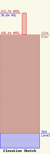
Site Elevation: 166.1 meters (545 ft) |
| Height of Structure: 36.6 meters (120 feet) |
| Overall Height Above Ground: 36.6 meters (120 feet) |
| Overall Height Above Mean Sea Level: 202.7 meters (665 feet) |
| Info |
| Contact Info | Skywaves Consulting LLC
4
Millbury, MA 01527-0004
David Doherty
(401) 354-2400
dave@skywaves.com |
