|
|
Antenna Structure Registration 1287334 |
 |
Registration Info | Registration Number: 1287334 |
| File Number: A0785552 |
| FAA Study: 2012-ASW-5977-OE |
| FAA Issue Date: 10/22/2012 |
| Status: Granted |
Structure Info
| Structure Type: LTOWER |
| Structure Coordinates: 34-47-58.3 N 92-30-8.4 W (NAD 83) |
| Structure Coordinates: 34-47-58.0 N 92-30-07.8 W (Converted to NAD 27) |
| Structure Address: Two Towers Road, Shinall Mountain |
| Structure City: Little Rock, AR |
| Structure County: Pulaski County |
| Painting & Lighting Info |
FAA Circular #: 70/7460-1K |
FAA Chapters: 4, 8, 12 |
Remarks: Removed expiration date from determination. Scenario 1./jjs/case#635066 |
| Elevation Info |
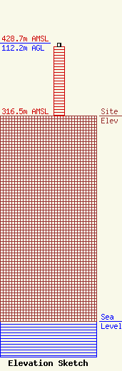
Site Elevation: 316.5 meters (1038 ft) |
| Height of Structure: 106.7 meters (350 feet) |
| Overall Height Above Ground: 112.2 meters (368 feet) |
| Overall Height Above Mean Sea Level: 428.7 meters (1406 feet) |
| Owner Info | City of Little Rock
720 W Markham Street
Little Rock, AR 72201
(501) 371-4540
lmartin@littlerock.org |
| Contact Info | City of Little Rock
720 W Markham Street
Little Rock, AR 72201
Karen Grimm
(501) 371-4540
kgrimm@littlerock.org |
