|
|
Antenna Structure Registration 1287546 |
 |
Registration Info | Registration Number: 1287546 |
| File Number: A1114830 |
| FAA Study: 2018-AGL-16133-OE |
| FAA Issue Date: 08/24/2018 |
| Status: Constructed |
| Date Constructed: 08/24/2018 |
Structure Info
| Structure Type: LTOWER |
| Structure Coordinates: 44-13-30.1 N 85-24-4.5 W (NAD 83) |
| Structure Coordinates: 44-13-30.1 N 85-24-04.3 W (Converted to NAD 27) |
| Structure Address: On The East Side Of Mackinaw Trail, 500 Feet South Of Professional Drive. |
| Structure City: Cadillac, MI |
| Structure County: Wexford County |
| Painting & Lighting Info |
FAA Chapters: NONE |
Remarks: PRIOR STUDY 2013-AGL-1095-OE |
| Elevation Info |
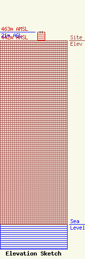
Site Elevation: 442 meters (1450 ft) |
| Height of Structure: 21 meters (69 feet) |
| Overall Height Above Ground: 21 meters (69 feet) |
| Overall Height Above Mean Sea Level: 463 meters (1519 feet) |
| Owner Info | MacDonald-Garber Broadcasting, Inc.
2095 U.S. 131 South
Petoskey, MI 49770
(231) 347-8713
tmac@106khq.com |
| Contact Info | MacDonald-Garber Broadcasting, Inc.
286
Petoskey, MI 49770
Brian Brachel
(231) 347-8713
wavetech@chartermi.net |
