|
|
Antenna Structure Registration 1287592 |
 |
Registration Info | Registration Number: 1287592 |
| File Number: A0862604 |
| FAA Study: 2012-ACE-3641-OE |
| FAA Issue Date: 11/05/2012 |
| Status: Constructed |
| Date Constructed: 10/21/2013 |
| FAA EMI: N |
Structure Info
| Structure Type: LTOWER |
| Structure Coordinates: 38-27-25.2 N 90-26-25.2 W (NAD 83) |
| Structure Coordinates: 38-27-25.0 N 90-26-24.8 W (Converted to NAD 27) |
| Structure Address: Nrf7, 1340 West Outer 21 Road |
| Structure City: Arnold, MO |
| Structure County: Jefferson County |
| Painting & Lighting Info |
FAA Circular #: 70/7460-1K |
FAA Chapters: 4, 8, 12 |
Remarks: PRIOR STUDY 2012-ACE-2347-OE. CHAPTERS 4, 8, 12 (1K). ADD SPECIAL CONDITION FOR LIGHTING DEVIATION. |
| Elevation Info |
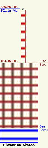
Site Elevation: 183.4 meters (602 ft) |
| Height of Structure: 149.4 meters (490 feet) |
| Overall Height Above Ground: 152.1 meters (499 feet) |
| Overall Height Above Mean Sea Level: 335.5 meters (1101 feet) |
| Owner Info | Jefferson County 9-1-1 Dispatch
5475 Buckeye Valley Drive
House Springs, MO 63051
(636) 797-9797
twilliams@jeffco911.org |
| Contact Info | RCC Consultants, Inc.
329 Brownstown Road
Renick, WV 24966-9649
John Pearson
(304) 497-3939
jpearson@rcc.com |
