|
|
Antenna Structure Registration 1287818 |
 |
Registration Info | Registration Number: 1287818 |
| File Number: A0891715 |
| FAA Study: 2012-ACE-3863-OE |
| FAA Issue Date: 12/05/2012 |
| Status: Constructed |
| Date Constructed: 01/31/2014 |
| FAA EMI: N |
Structure Info
| Structure Type: LTOWER |
| Structure Coordinates: 38-24-32.5 N 90-39-35.4 W (NAD 83) |
| Structure Coordinates: 38-24-32.3 N 90-39-34.9 W (Converted to NAD 27) |
| Structure Address: Nrf10, 4098 Rolling Stone Lane |
| Structure City: House Springs, MO |
| Structure County: Jefferson County |
| Painting & Lighting Info |
FAA Circular #: 70/7460-1K |
FAA Chapters: 4, 8, 12 |
Remarks: PRIOR STUDY 2012-ACE-3642-OE. FAA CHAPTERS = 4, 8, 12 (1K) - ADD SPECIAL CONDITION FOR LIGHTING DEVIATION |
| Elevation Info |
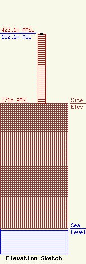
Site Elevation: 271 meters (889 ft) |
| Height of Structure: 149.4 meters (490 feet) |
| Overall Height Above Ground: 152.1 meters (499 feet) |
| Overall Height Above Mean Sea Level: 423.1 meters (1388 feet) |
| Owner Info | Jefferson County 9-1-1 Dispatch
5475 Buckeye Valley Drive
House Springs, MO 63051
(636) 797-9797
twilliams@jeffco911.org |
| Contact Info | RCC Consultants, Inc.
329 Brownstown Road
Renick, WV 24966-9649
John Pearson
(304) 497-3939
jpearson@rcc.com |
