|
|
Antenna Structure Registration 1288320 |
 |
Registration Info | Registration Number: 1288320 |
| File Number: A0861880 |
| FAA Study: 2013-ACE-200-OE |
| FAA Issue Date: 03/21/2013 |
| Status: Constructed |
| Date Constructed: 10/21/2013 |
| FAA EMI: N |
Structure Info
| Structure Type: GTOWER |
| Structure Coordinates: 37-48-13.9 N 97-20-55.4 W (NAD 83) |
| Structure Coordinates: 37-48-13.9 N 97-20-54.2 W (Converted to NAD 27) |
| Structure Address: N.w.1/4 Section 8 Twp 26 S.r.e. |
| Structure City: Park City, KS |
| Structure County: Sedgwick County |
| Painting & Lighting Info |
FAA Circular #: 70/7460-1K |
FAA Chapters: 4, 8, 12 |
Remarks: Removed expiration date from determination. Scenario 1./jjs/case#635066 |
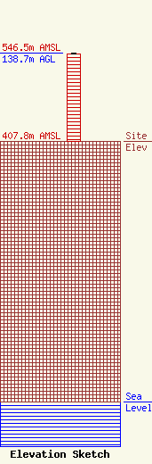
| Elevation Info |
Site Elevation: 407.8 meters (1338 ft) |
| Height of Structure: 137.2 meters (450 feet) |
| Overall Height Above Ground: 138.7 meters (455 feet) |
| Overall Height Above Mean Sea Level: 546.5 meters (1793 feet) |
| Owner Info | Kansas Public Telecommunications Service, Inc.
320 W. 21st Street N.
Wichita, KS 67203
(316) 838-3090
dmcclintock@kpts.org |
| Contact Info | Kansas Public Telecommunications Service, Inc.
320 W. 21st Street N
Wichita, KS 67203
David McClintock
(316) 838-3090
dmcclintock@kpts.org |
