|
|
Antenna Structure Registration 1288341 |
 |
Registration Info | Registration Number: 1288341 |
| File Number: A0990449 |
| FAA Study: 2013-AWP-2574-OE |
| FAA Issue Date: 07/24/2013 |
| Status: Granted |
| Date Constructed: 07/30/2013 |
| FAA EMI: N |
| NEPA: N |
Structure Info
| Structure Type: MAST |
| Structure Coordinates: 34-9-47.3 N 118-10-0.7 W (NAD 83) |
| Structure Coordinates: 34-09-47.3 N 118-09-57.4 W (Converted to NAD 27) |
| Structure Address: 1001 Rosebwol Drive |
| Structure City: Pasadena, CA |
| Structure County: Los Angeles County |
| Painting & Lighting Info |
FAA Chapters: NONE |
Remarks: Removed expiration date from determination. Scenario 1./jjs/case#635066 |
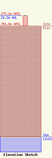
| Elevation Info |
Site Elevation: 254.8 meters (836 ft) |
| Height of Structure: 24.3 meters (80 feet) |
| Overall Height Above Ground: 24.3 meters (80 feet) |
| Overall Height Above Mean Sea Level: 279.1 meters (916 feet) |
| Owner Info | Los Angeles SMSA Limited Partnership
1120 Sanctuary Pkwy
Alpharetta, GA 30009
(770) 797-1070
Network.Regulatory@VerizonWireless.com |
| Contact Info | Los Angeles SMSA Limited Partnership
1120 Sanctuary Pkwy
Alpharetta, GA 30009
Regulatory Manager
(770) 797-1070
Network.Regulatory@VerizonWireless.com |
