|
|
Antenna Structure Registration 1288556 |
 |
Registration Info | Registration Number: 1288556 |
| File Number: A1276226 |
| FAA Study: 2012-AEA-4323-OE |
| FAA Issue Date: 09/13/2012 |
| Status: Constructed |
| Date Constructed: 11/26/2013 |
| FAA EMI: N |
Structure Info
| Structure Type: LTOWER |
| Structure Coordinates: 38-25-4.1 N 82-26-57.6 W (NAD 83) |
| Structure Coordinates: 38-25-03.8 N 82-26-58.0 W (Converted to NAD 27) |
| Structure Address: 555 5th Avenue |
| Structure City: Huntington, WV |
| Structure County: Cabell County |
| Painting & Lighting Info |
FAA Circular #: 70/7460-1K |
FAA Chapters: 4, 8, 12 |
Remarks: Removed expiration date from determination. Scenario 1./jjs/case#635066 |
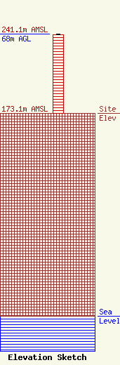
| Elevation Info |
Site Elevation: 173.1 meters (568 ft) |
| Height of Structure: 67.1 meters (220 feet) |
| Overall Height Above Ground: 68 meters (223 feet) |
| Overall Height Above Mean Sea Level: 241.1 meters (791 feet) |
| Owner Info | Kindred Communications, Inc.
555 Fifth Avenue
Huntington, WV 25701
(304) 523-8401
mikek@kindredcom.net |
| Contact Info | Shainis & Peltzman, Chartered
1850 M Street, NW
Washington, DC 20036
Susan Marshall
(202) 293-0011
susan@s-plaw.com |
