|
|
Antenna Structure Registration 1289884 |
 |
Registration Info | Registration Number: 1289884 |
| File Number: A1154302 |
| FAA Study: 2013-AWP-4600-OE |
| FAA Issue Date: 09/10/2013 |
| Status: Constructed |
| Date Constructed: 01/01/2000 |
Structure Info
| Structure Type: LTOWER |
| Structure Coordinates: 35-35-42.6 N 114-15-10.8 W (NAD 83) |
| Structure Coordinates: 35-35-42.6 N 114-15-07.9 W (Converted to NAD 27) |
| Structure Address: 16185 North Florence Lane |
| Structure City: Dolan Springs, AZ |
| Structure County: Mohave County |
| Painting & Lighting Info |
FAA Circular #: 70/7460-1K |
FAA Chapters: 4, 8, 12 |
Remarks: PRIOR STUDY 2000-AWP-1087-OE |
| Elevation Info |
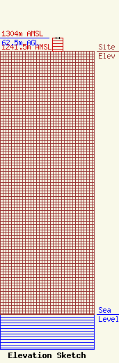
Site Elevation: 1241.5 meters (4073 ft) |
| Height of Structure: 62.5 meters (205 feet) |
| Overall Height Above Ground: 62.5 meters (205 feet) |
| Overall Height Above Mean Sea Level: 1304 meters (4278 feet) |
| Owner Info | Cellco Partnership
5055 North Point Pkwy
Alpharetta, GA 30022
(770) 797-1070
Network.Regulatory@verizonwireless.com |
| Contact Info | Cellco Partnership
5055 North Point Pkwy
Alpharetta, GA 30022
Regulatory Manager
(770) 797-1070
Network.Regulatory@verizonwireless.com |
