|
|
Antenna Structure Registration 1291117 |
 |
Registration Info | Registration Number: 1291117 |
| File Number: A0939434 |
| FAA Study: 2015-ASW-1455-OE |
| FAA Issue Date: 03/26/2015 |
| Status: Constructed |
| Date Constructed: 05/19/2014 |
Structure Info
| Structure Type: MTOWER |
| Structure Coordinates: 34-53-55.4 N 92-26-21.2 W (NAD 83) |
| Structure Coordinates: 34-53-55.1 N 92-26-20.6 W (Converted to NAD 27) |
| Structure Address: 16272 Vista Del Rio Drive (ar16869-a) |
| Structure City: North Little Rock, AR |
| Structure County: Pulaski County |
| Painting & Lighting Info |
FAA Chapters: NONE |
Remarks: PRIOR STUDY 2014-ASW-819-OE |
| Elevation Info |
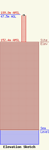
Site Elevation: 152.4 meters (500 ft) |
| Height of Structure: 45.4 meters (149 feet) |
| Overall Height Above Ground: 47.5 meters (156 feet) |
| Overall Height Above Mean Sea Level: 199.9 meters (656 feet) |
| Owner Info | SBA Towers VI, LLC
8051 Congress Avenue
Boca Raton, FL 33487
(561) 995-7670
ERoach@sbasite.com |
| Contact Info | SBA Towers VI, LLC
8051 Congress Avenue
Boca Raton, FL 33487
(561) 995-7670
ERoach@sbasite.com |
