|
|
Antenna Structure Registration 1293077 |
 |
Registration Info | Registration Number: 1293077 |
| File Number: A0898232 |
| FAA Study: 2014-ASO-5622-OE |
| FAA Issue Date: 05/16/2014 |
| Status: Granted |
Structure Info
| Structure Type: GTOWER |
| Structure Coordinates: 31-18-2.3 N 85-35-4.3 W (NAD 83) |
| Structure Coordinates: 31-18-01.7 N 85-35-04.5 W (Converted to NAD 27) |
| Structure Address: Off Of County Road 9 |
| Structure City: Newton, AL |
| Structure County: Dale County |
| Painting & Lighting Info |
FAA Circular #: 70/7460-1K |
FAA Chapters: 12, 3, 4, 5 |
Remarks: PRIOR STUDY 2013-ASO-4692-OE ADD SPECIAL CONDITION FOR BIRD LIGHT DEVIATION. |
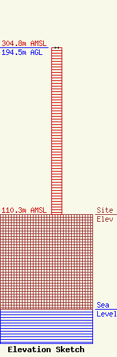
| Elevation Info |
Site Elevation: 110.3 meters (362 ft) |
| Height of Structure: 194.5 meters (638 feet) |
| Overall Height Above Ground: 194.5 meters (638 feet) |
| Overall Height Above Mean Sea Level: 304.8 meters (1000 feet) |
| Owner Info | Gulf South Communications, Inc
3245 Montgomery Highway
Dothan, GA 36303
(334) 791-9424
autumn.dubois@eca-usa.com |
| Contact Info | ECA
1375 Union Hill Industrial Bvld
Alpharetta, GA 30004
Autumn DuBois
(770) 667-2040
autumn.dubois@eca-usa.com |
