|
|
Antenna Structure Registration 1293585 |
 |
Registration Info | Registration Number: 1293585 |
| File Number: A1350411 |
| FAA Study: 2015-ASO-22141-OE |
| FAA Issue Date: 03/04/2016 |
| Status: Constructed |
| Date Constructed: 10/24/2014 |
Structure Info
| Structure Type: LTOWER |
| Structure Coordinates: 27-19-16.9 N 82-26-58.1 W (NAD 83) |
| Structure Coordinates: 27-19-15.7 N 82-26-58.8 W (Converted to NAD 27) |
| Structure Address: 6050 Porter Way |
| Structure City: Sarasota, FL |
| Structure County: Sarasota County |
| Painting & Lighting Info |
FAA Circular #: 70/7460-1K |
FAA Chapters: 4, 8, 12 |
Remarks: PRIOR STUDY 2014-ASO-3978-OE |
| Elevation Info |
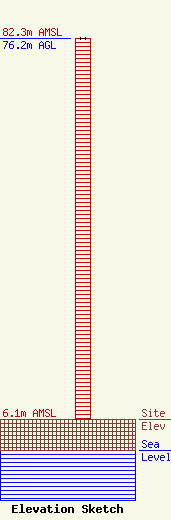
Site Elevation: 6.1 meters (20 ft) |
| Height of Structure: 76.2 meters (250 feet) |
| Overall Height Above Ground: 76.2 meters (250 feet) |
| Overall Height Above Mean Sea Level: 82.3 meters (270 feet) |
| Owner Info | Sarasota County Government
6050 Porter Way
Sarasota, FL 34232
(941) 861-5285
brhodes@scgov.net |
| Contact Info | Sarasota County Government
6050 Porter Way
Sarasota, FL 34232
Bill Rhodes
(941) 861-5285
brhodes@scgov.net |
