|
|
Antenna Structure Registration 1294498 |
 |
Registration Info | Registration Number: 1294498 |
| File Number: A1382716 |
| FAA Study: 2014-ANE-2542-OE |
| FAA Issue Date: 01/06/2015 |
| Status: Constructed |
| Date Constructed: 01/21/2016 |
Structure Info
| Structure Type: LTOWER |
| Structure Coordinates: 41-37-20.2 N 70-55-7.5 W (NAD 83) |
| Structure Coordinates: 41-37-19.8 N 70-55-09.4 W (Converted to NAD 27) |
| Structure Address: 503 Mcarthur Drive |
| Structure City: New Bedford, MA |
| Structure County: Bristol County |
| Painting & Lighting Info |
FAA Circular #: 70/7460-1K |
FAA Chapters: 4, 9, 12 |
Remarks: PRIOR STUDY 2014-ANE-586-OE. FAA CHAPTERS 4, 9, 12 70/7460-1K with bird deviation special condition. |
| Elevation Info |
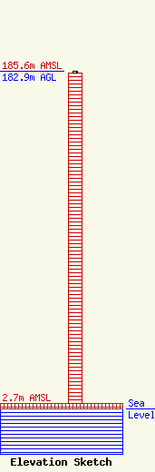
Site Elevation: 2.7 meters (9 ft) |
| Height of Structure: 182 meters (597 feet) |
| Overall Height Above Ground: 182.9 meters (600 feet) |
| Overall Height Above Mean Sea Level: 185.6 meters (609 feet) |
| Owner Info | WIRELESS EDGE TOWERS III, LLC
38 W. Market Street
Rhinebeck, NY 12572
(914) 712-0000
arthur@wirelessedge.com |
| Contact Info | WIRELESS EDGE TOWERS III, LLC
38 W. Market Street
Rhinebeck, NY 12572
John Arthur
(914) 714-0000
arthur@wirelessedge.com |
