|
|
Antenna Structure Registration 1296350 |
 |
Registration Info | Registration Number: 1296350 |
| File Number: A1130253 |
| FAA Study: 2018-AWP-15798-OE |
| FAA Issue Date: 11/07/2018 |
| Status: Constructed |
| Date Constructed: 07/31/2015 |
Structure Info
| Structure Type: MTOWER |
| Structure Coordinates: 34-6-11.1 N 118-4-34.3 W (NAD 83) |
| Structure Coordinates: 34-06-11.1 N 118-04-31.1 W (Converted to NAD 27) |
| Structure Address: 8838 E Las Tunas Drive |
| Structure City: Temple City, CA |
| Structure County: Los Angeles County |
| Painting & Lighting Info |
FAA Chapters: NONE |
Remarks: PRIOR STUDY 2016-AWP-12348-OE |
Remarks: Removed expiration date from determination. Scenario 1./jjs/case#635066 |
Remarks: PRIOR STUDY 2016-AWP-12348-OE |
| Elevation Info |
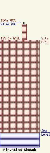
Site Elevation: 125.6 meters (412 ft) |
| Height of Structure: 21.6 meters (71 feet) |
| Overall Height Above Ground: 24.4 meters (80 feet) |
| Overall Height Above Mean Sea Level: 150 meters (492 feet) |
| Owner Info | Los Angeles Regional Interoperable Communications System Joint Powers Authority
2525 Corporate Place, Suite 100
Monterey Park, CA 91754-7661
(323) 881-8291
info@la-rics.org |
| Contact Info | Los Angeles Regional Interoperable Communications System Joint Powers Authority
2525 Corporate Place, Suite 100
Monterey Park, CA 91754
(323) 881-8291
scott.edson@la-rics.org |
