|
|
Antenna Structure Registration 1297241 |
 |
Registration Info | Registration Number: 1297241 |
| File Number: A0981239 |
| FAA Study: 2015-AGL-13352-OE |
| FAA Issue Date: 10/07/2015 |
| Status: Constructed |
| Date Constructed: 09/01/1994 |
Structure Info
| Structure Type: GTOWER |
| Structure Coordinates: 43-36-25.9 N 84-43-51.7 W (NAD 83) |
| Structure Coordinates: 43-36-25.8 N 84-43-51.7 W (Converted to NAD 27) |
| Structure Address: 5847 Venture Way |
| Structure City: Mount Pleasant, MI |
| Structure County: Isabella County |
| Painting & Lighting Info |
FAA Chapters: NONE |
| Elevation Info |
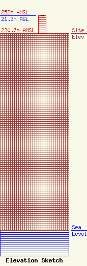
Site Elevation: 230.7 meters (757 ft) |
| Height of Structure: 21.3 meters (70 feet) |
| Overall Height Above Ground: 21.3 meters (70 feet) |
| Overall Height Above Mean Sea Level: 252 meters (827 feet) |
| Owner Info | Grenax Broadcasting, LLC
5847 Venture Way
Mount Pleasant, MI 48858
(989) 772-4173
kent@wcfx.com |
| Contact Info | Fletcher, Heald & Hildreth, PLC
1300 N. 17th Street
Arlington, VA 22209
Scott Johnson
(703) 812-0474
sjohnson@fhhlaw.com |
