|
|
Antenna Structure Registration 1297413 |
 |
Registration Info | Registration Number: 1297413 |
| File Number: A1141351 |
| FAA Study: 2015-ASW-6338-OE |
| FAA Issue Date: 08/28/2015 |
| Status: Constructed |
| Date Constructed: 03/30/2016 |
Structure Info
| Structure Type: LTOWER |
| Structure Coordinates: 30-51-48.4 N 91-1-23.1 W (NAD 83) |
| Structure Coordinates: 30-51-47.7 N 91-01-22.7 W (Converted to NAD 27) |
| Structure Address: 11618 Marston St |
| Structure City: Clinton, LA |
| Structure County: East Feliciana Parish |
| Painting & Lighting Info |
FAA Circular #: 70/7460-1K |
FAA Chapters: 4, 8, 12 |
Remarks: Removed expiration date from determination. Scenario 1./jjs/case#635066 |
| Elevation Info |
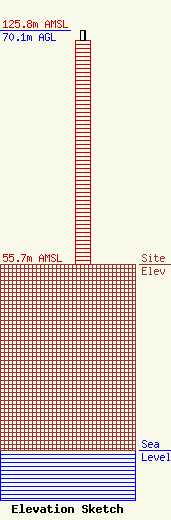
Site Elevation: 55.7 meters (183 ft) |
| Height of Structure: 67.1 meters (220 feet) |
| Overall Height Above Ground: 70.1 meters (230 feet) |
| Overall Height Above Mean Sea Level: 125.8 meters (413 feet) |
| Owner Info | Entergy Services, LLC
425 West Capitol Ave.
551
Little Rock, AR 72203-0551
(501) 377-5609
TelecomMgr@Entergy.com |
| Contact Info | Entergy Services, LLC
425 West Capitol Ave.
551
Little Rock, AR 72203-0551
Steven Paquette
(501) 377-5609
TelecomMgr@Entergy.com |
