|
|
Antenna Structure Registration 1297852 |
 |
Registration Info | Registration Number: 1297852 |
| File Number: A0985625 |
| FAA Study: 2015-AWP-8508-OE |
| FAA Issue Date: 10/16/2015 |
| Status: Constructed |
| Date Constructed: 01/01/2008 |
Structure Info
| Structure Type: POLE |
| Structure Coordinates: 40-50-47.9 N 115-44-52.3 W (NAD 83) |
| Structure Coordinates: 40-50-48.2 N 115-44-49.1 W (Converted to NAD 27) |
| Structure Address: 1750 Manzanita |
| Structure City: Elko, NV |
| Structure County: Elko County |
| Painting & Lighting Info |
FAA Chapters: NONE |
Remarks: Removed expiration date from determination. Scenario 1./jjs/case#635066 |
| Elevation Info |
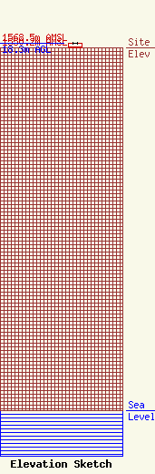
Site Elevation: 1550.2 meters (5086 ft) |
| Height of Structure: 18.3 meters (60 feet) |
| Overall Height Above Ground: 18.3 meters (60 feet) |
| Overall Height Above Mean Sea Level: 1568.5 meters (5146 feet) |
| Owner Info | RUBY RADIO CORPORATION
1750 MANZANITA
ELKO, NV 89801
(775) 777-1196
KEN@RUBYRADIO.FM |
| Contact Info | HATFIELD & DAWSON CONSULTING ENGINEERS
9500 GREENWOOD AVE N
SEATTLE, WA 98103
ERIK SWANSON
(206) 783-9151
ESWANSON@HATDAW.COM |
