|
|
Antenna Structure Registration 1298096 |
 |
Registration Info | Registration Number: 1298096 |
| File Number: A1206579 |
| FAA Study: 2015-AGL-11019-OE |
| FAA Issue Date: 08/14/2015 |
| Status: Constructed |
| Date Constructed: 01/23/2016 |
Structure Info
| Structure Type: LTOWER |
| Structure Coordinates: 46-17-29.8 N 96-6-57.7 W (NAD 83) |
| Structure Coordinates: 46-17-29.9 N 96-06-56.5 W (Converted to NAD 27) |
| Structure Address: 728 Western Avenue |
| Structure City: Fergus Falls, MN |
| Structure County: Otter Tail County |
| Painting & Lighting Info |
FAA Chapters: NONE |
Remarks: Removed expiration date from determination. Scenario 1./jjs/case#635066 |
| Elevation Info |
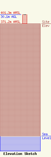
Site Elevation: 371.2 meters (1218 ft) |
| Height of Structure: 30.1 meters (99 feet) |
| Overall Height Above Ground: 30.1 meters (99 feet) |
| Overall Height Above Mean Sea Level: 401.3 meters (1317 feet) |
| Owner Info | Leighton Radio Holdings, Inc.
1458
St. Cloud, MN 56302
(320) 251-1450
tabfalter@leightonbroadcasting.com |
| Contact Info | Leighton Radio Holdings, Inc.
1458
St. Cloud, MN 56302
Tony Abfalter
(320) 251-1450
tabfalter@leightonbroadcasting.com |
