|
|
Antenna Structure Registration 1298729 |
 |
Registration Info | Registration Number: 1298729 |
| File Number: A1070021 |
| FAA Study: 2015-ASW-9312-OE |
| FAA Issue Date: 02/17/2016 |
| Status: Constructed |
| Date Constructed: 03/01/2017 |
Structure Info
| Structure Type: GTOWER |
| Structure Coordinates: 30-52-46.0 N 90-58-42.7 W (NAD 83) |
| Structure Coordinates: 30-52-45.4 N 90-58-42.3 W (Converted to NAD 27) |
| Structure Address: Clinton Tower - 14024 La Hwy 10 |
| Structure City: Clinton, LA |
| Structure County: East Feliciana Parish |
| Painting & Lighting Info |
FAA Circular #: 70/7460-1L |
FAA Chapters: 4, 8, 12 |
Remarks: PRIOR STUDY 2015-ASW-5365-OE |
Remarks: Removed expiration date from determination. Scenario 1./jjs/case#635066 |
Remarks: PRIOR STUDY 2015-ASW-5365-OE |
Remarks: Removed expiration date from determination. Scenario 1./jjs/case#635066 |
| Elevation Info |
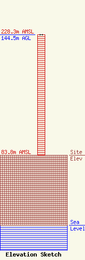
Site Elevation: 83.8 meters (275 ft) |
| Height of Structure: 144.5 meters (474 feet) |
| Overall Height Above Ground: 144.5 meters (474 feet) |
| Overall Height Above Mean Sea Level: 228.3 meters (749 feet) |
| Owner Info | DIXIE ELECTRIC MEMBERSHIP CORPORATION INC.
16262 Wax Rd.
Greenwell Springs, LA 70739
(225) 261-1221
johnv@demco.org |
| Contact Info | Keller and Heckman LLP
1001 G Street NW, Suite 500 West
Washington, DC 20001
K LAW
(202) 434-4100
telecomlicensing@khlaw.com |
