|
|
Antenna Structure Registration 1300713 |
 |
Registration Info | Registration Number: 1300713 |
| File Number: A1052533 |
| FAA Study: 2016-AWP-9265-OE |
| FAA Issue Date: 04/23/2018 |
| Status: Granted |
Structure Info
| Structure Type: MTOWER |
| Structure Coordinates: 34-7-42.9 N 118-4-20.9 W (NAD 83) |
| Structure Coordinates: 34-07-42.9 N 118-04-17.7 W (Converted to NAD 27) |
| Structure Address: 7232 Rosemead Blvd |
| Structure City: San Gabriel, CA |
| Structure County: Los Angeles County |
| Painting & Lighting Info |
FAA Chapters: NONE |
Remarks: Removed expiration date from determination. Scenario 1./jjs/case#635066 |
| Elevation Info |
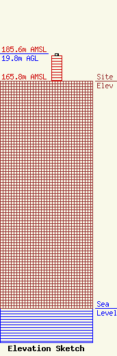
Site Elevation: 165.8 meters (544 ft) |
| Height of Structure: 18.3 meters (60 feet) |
| Overall Height Above Ground: 19.8 meters (65 feet) |
| Overall Height Above Mean Sea Level: 185.6 meters (609 feet) |
| Owner Info | CCTM! LLC
2000 Corporate Drive
Canonsburg, PA 15317
(724) 416-2000
Regulatory.Department@Crowncastle.com |
| Contact Info | Crown Castle
2000 Corporate Drive
Canonsburg, PA 15317
Don Snyder
(724) 416-2470
Don.Snyder@Crowncastle.com |
