|
|
Antenna Structure Registration 1301089 |
 |
Registration Info | Registration Number: 1301089 |
| File Number: A1384642 |
| FAA Study: 2016-AEA-10901-OE |
| FAA Issue Date: 12/21/2016 |
| Status: Constructed |
| Date Constructed: 08/31/2000 |
Structure Info
| Structure Type: GTOWER |
| Structure Coordinates: 38-30-18.0 N 75-38-36.0 W (NAD 83) |
| Structure Coordinates: 38-30-17.6 N 75-38-37.3 W (Converted to NAD 27) |
| Structure Address: Wboc-tv Tower Site, 1616 Draper Lane,ralph's Road Sw, |
| Structure City: Laurel, DE |
| Structure County: Sussex County |
| Painting & Lighting Info |
FAA Circular #: 70/7460-1L |
FAA Chapters: 4, 7, 12 |
Remarks: Removed expiration date from determination. Scenario 1./jjs/case#635066 |
| Elevation Info |
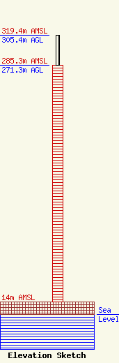
Site Elevation: 14 meters (46 ft) |
| Height of Structure: 271.3 meters (890 feet) |
| Overall Height Above Ground: 305.4 meters (1002 feet) |
| Overall Height Above Mean Sea Level: 319.4 meters (1048 feet) |
| Owner Info | Draper Media, Inc.
1729 N. Salisbury Boulevard
Salisbury, MD 21801
(410) 479-1111
bvernon@drapermedia.com |
| Contact Info | Cooley LLP
1299 Pennsylvania Ave., NW, # 700
Washington, DC 20004
Jason Rademacher
(202) 776-2630
jrademacher@cooley.com |
