|
|
Antenna Structure Registration 1302702 |
 |
Registration Info | Registration Number: 1302702 |
| File Number: A1130377 |
| FAA Study: 2016-ASW-11529-OE |
| FAA Issue Date: 06/13/2018 |
| Status: Constructed |
| Date Constructed: 01/16/2019 |
Structure Info
| Structure Type: GTOWER |
| Structure Coordinates: 30-47-58.2 N 91-6-47.0 W (NAD 83) |
| Structure Coordinates: 30-47-57.5 N 91-06-46.6 W (Converted to NAD 27) |
| Structure Address: 4603 Brown Rd |
| Structure City: Ethel, LA |
| Structure County: East Feliciana Parish |
| Painting & Lighting Info |
FAA Circular #: 70/7460-1L |
FAA Chapters: 4, 8, 12 |
Remarks: Removed expiration date from determination. Scenario 1./jjs/case#635066 |
| Elevation Info |
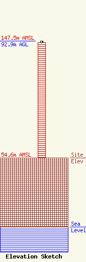
Site Elevation: 54.6 meters (179 ft) |
| Height of Structure: 91.7 meters (301 feet) |
| Overall Height Above Ground: 92.9 meters (305 feet) |
| Overall Height Above Mean Sea Level: 147.5 meters (484 feet) |
| Owner Info | Tillman Infrastructure, LLC
152 West 57th Street
New York, NY 10019
(212) 706-1677
dmstipo@tillmaninfrastructure.com |
| Contact Info | Tillman Infrastructure, LLC
152 West 57th Street
New York, NY 10019
(212) 706-1677
dmstipo@tillmaninfrastructure.com |
