|
|
Antenna Structure Registration 1304782 |
 |
Registration Info | Registration Number: 1304782 |
| File Number: A1146380 |
| FAA Study: 2017-ANM-7-NRA |
| FAA Issue Date: 02/27/2017 |
| Status: Constructed |
| Date Constructed: 01/16/2018 |
Structure Info
| Structure Type: LTOWER |
| Structure Coordinates: 46-36-9.0 N 111-59-44.4 W (NAD 83) |
| Structure Coordinates: 46-36-09.2 N 111-59-41.4 W (Converted to NAD 27) |
| Structure Address: 2520 Airport Rd |
| Structure City: Helena, MT |
| Structure County: Lewis and Clark County |
| Painting & Lighting Info |
FAA Chapters: NONE |
| Elevation Info |
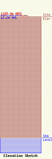
Site Elevation: 1187.2 meters (3895 ft) |
| Height of Structure: 12.2 meters (40 feet) |
| Overall Height Above Ground: 12.2 meters (40 feet) |
| Overall Height Above Mean Sea Level: 1199.4 meters (3935 feet) |
| Owner Info | The Montana Radio Company, LLC
2520 Airport Rd
Helena, MT 59601
(406) 438-6353
kevin@montanaradio.com |
| Contact Info | The Montana Radio Company, LLC
2520 Airport Rd
Helena, MT 59601
Kevin Terry
(406) 438-6353
kevin@montanaradio.com |
