|
|
Antenna Structure Registration 1307465 |
 |
Registration Info | Registration Number: 1307465 |
| File Number: A1134428 |
| FAA Study: 2018-ASO-13837-OE |
| FAA Issue Date: 01/24/2020 |
| Status: Granted |
| Date Constructed: 04/10/2019 |
Structure Info
| Structure Type: LTOWER |
| Structure Coordinates: 35-54-6.3 N 80-6-2.2 W (NAD 83) |
| Structure Coordinates: 35-54-05.8 N 80-06-03.0 W (Converted to NAD 27) |
| Structure Address: 80 Winding Creek Road |
| Structure City: Thomasville, NC |
| Structure County: Davidson County |
| Painting & Lighting Info |
FAA Circular #: 70/7460-1L |
FAA Chapters: 4, 8, 12 |
Remarks: PRIOR STUDY 2017-ASO-19290-OE |
| Elevation Info |
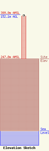
Site Elevation: 247.8 meters (813 ft) |
| Height of Structure: 146.3 meters (480 feet) |
| Overall Height Above Ground: 152.1 meters (499 feet) |
| Overall Height Above Mean Sea Level: 399.9 meters (1312 feet) |
| Owner Info | Davidson County Government
913 Greensboro Street
1067
Lexington, NC 27292
(336) 242-2213
Casey.Smith@DavidsonCountyNC.gov |
| Contact Info | Engineered Tower Solutions, PLLC
3227 Wellington Court
Raleigh, NC 27615
James DICKERSON
(919) 280-4191
ERIC.DICKERSON@ETS-PLLC.COM |
