|
|
Antenna Structure Registration 1308563 |
 |
Registration Info | Registration Number: 1308563 |
| File Number: A1239172 |
| FAA Study: 2018-AWP-9598-OE |
| FAA Issue Date: 06/06/2018 |
| Status: Cancelled |
Structure Info
| Structure Type: UPOLE |
| Structure Coordinates: 34-12-37.6 N 118-13-49.8 W (NAD 83) |
| Structure Coordinates: 34-12-37.6 N 118-13-46.5 W (Converted to NAD 27) |
| Structure Address: 2365 Montrose Ave (sv12154b) |
| Structure City: Montrose, CA |
| Structure County: Los Angeles County |
| Painting & Lighting Info |
FAA Chapters: NONE |
Remarks: Removed expiration date from determination. Scenario 1./jjs/case#635066 |
| Elevation Info |
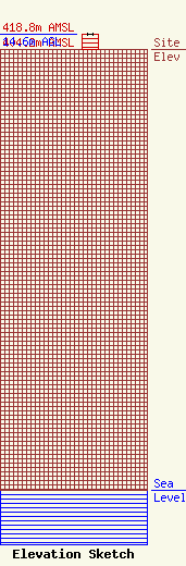
Site Elevation: 404.2 meters (1326 ft) |
| Height of Structure: 14.6 meters (48 feet) |
| Overall Height Above Ground: 14.6 meters (48 feet) |
| Overall Height Above Mean Sea Level: 418.8 meters (1374 feet) |
| Owner Info | T-Mobile West LLC
12920 SE 38th Street
Bellevue, WA 98006
(425) 383-8401
FCCRegulatoryComplianceContact@T-Mobile.com |
| Contact Info | T-Mobile West LLC
12920 SE 38th Street
Bellevue, WA 98006
(425) 383-8401
FCCRegulatoryComplianceContact@T-Mobile.com |
