|
|
Antenna Structure Registration 1308645 |
 |
Registration Info | Registration Number: 1308645 |
| File Number: A1107715 |
| FAA Study: 2018-ASW-11162-OE |
| FAA Issue Date: 02/20/2020 |
| Status: Granted |
Structure Info
| Structure Type: MTOWER |
| Structure Coordinates: 34-47-33.0 N 92-23-50.5 W (NAD 83) |
| Structure Coordinates: 34-47-32.7 N 92-23-49.9 W (Converted to NAD 27) |
| Structure Address: 11120 Cantrell Road |
| Structure City: Little Rock, AR |
| Structure County: Pulaski County |
| Painting & Lighting Info |
FAA Chapters: NONE |
| Elevation Info |
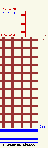
Site Elevation: 160 meters (525 ft) |
| Height of Structure: 45.7 meters (150 feet) |
| Overall Height Above Ground: 45.7 meters (150 feet) |
| Overall Height Above Mean Sea Level: 205.7 meters (675 feet) |
| Owner Info | Acme Commercial Properties, L.L.C.
PO Box 6060
Abilene, TX 79608
(325) 691-0495
wharkins@insitewireless.com |
| Contact Info | Acme Commercial Properties, L.L.C.
PO Box 6060
Abilene, TX 79608
(325) 691-0495
wharkins@insitewireless.com |
