|
|
Antenna Structure Registration 1308672 |
 |
Registration Info | Registration Number: 1308672 |
| File Number: A1239212 |
| FAA Study: 2023-AWP-2071-OE |
| FAA Issue Date: 02/15/2023 |
| Status: Constructed |
| Date Constructed: 06/23/2020 |
Structure Info
| Structure Type: LTOWER |
| Structure Coordinates: 34-9-36.0 N 118-11-3.4 W (NAD 83) |
| Structure Coordinates: 34-09-36.0 N 118-11-00.1 W (Converted to NAD 27) |
| Structure Address: 2010 Glen Oaks Blvd. |
| Structure City: Pasadena, CA |
| Structure County: Los Angeles County |
| Painting & Lighting Info |
FAA Chapters: NONE |
Remarks: PRIOR STUDY 2018-AWP-16730-OE |
| Elevation Info |
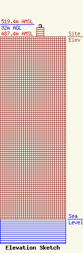
Site Elevation: 487.4 meters (1599 ft) |
| Height of Structure: 24.4 meters (80 feet) |
| Overall Height Above Ground: 32 meters (105 feet) |
| Overall Height Above Mean Sea Level: 519.4 meters (1704 feet) |
| Owner Info | Los Angeles Regional Interoperable Communications System (LA-RICS) Joint Power Authority c/o Pyramid Network Services
725 S. Figueroa Street
Los Angeles, CA 90017
(315) 857-6667
swoodward@pyramidns.com |
| Contact Info | Los Angeles Regional Interoperable Communications System (LA-RICS) Joint Power Authority
2525 Corporate Pl.
Monterey Park, CA 91754
(323) 881-8049
info@la-rics.org |
