|
|
Antenna Structure Registration 1310021 |
 |
Registration Info | Registration Number: 1310021 |
| File Number: A1215633 |
| FAA Study: 2019-AWP-386-OE |
| FAA Issue Date: 02/28/2019 |
| Status: Constructed |
| Date Constructed: 03/15/2022 |
Structure Info
| Structure Type: BANT |
| Structure Coordinates: 34-7-52.6 N 118-3-15.6 W (NAD 83) |
| Structure Coordinates: 34-07-52.6 N 118-03-12.4 W (Converted to NAD 27) |
| Structure Address: 660 West Huntington Drive (ie04283a) |
| Structure City: Arcadia, CA |
| Structure County: Los Angeles County |
| Painting & Lighting Info |
FAA Chapters: NONE |
Remarks: Removed expiration date from determination. Scenario 1./jjs/case#635066 |
| Elevation Info |
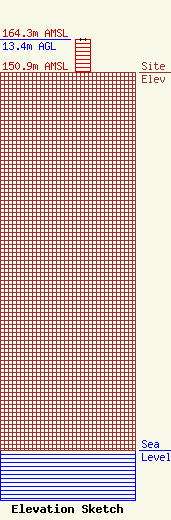
Site Elevation: 150.9 meters (495 ft) |
| Height of Structure: 13.4 meters (44 feet) |
| Overall Height Above Ground: 13.4 meters (44 feet) |
| Overall Height Above Mean Sea Level: 164.3 meters (539 feet) |
| Owner Info | T-Mobile West LLC
12920 SE 38th Street
Bellevue, WA 98006
(425) 383-8401
FCCRegulatoryComplianceContact@T-Mobile.com |
| Contact Info | T-Mobile West LLC
12920 SE 38th Street
Bellevue, WA 98006
(425) 383-8401
FCCRegulatoryComplianceContact@T-Mobile.com |
