|
|
Antenna Structure Registration 1313000 |
 |
Registration Info | Registration Number: 1313000 |
| File Number: A1149356 |
| FAA Study: 2019-AGL-8212-OE |
| FAA Issue Date: 08/26/2019 |
| Status: Constructed |
| Date Constructed: 12/09/2019 |
Structure Info
| Structure Type: LTOWER |
| Structure Coordinates: 45-55-39.4 N 89-15-20.3 W (NAD 83) |
| Structure Coordinates: 45-55-39.6 N 89-15-19.8 W (Converted to NAD 27) |
| Structure Address: 909 N. Railroad Street |
| Structure City: Eagle River, WI |
| Structure County: Vilas County |
| Painting & Lighting Info |
FAA Circular #: 70/7460-1L |
FAA Chapters: 4, 5, 12 |
| Elevation Info |
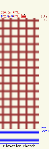
Site Elevation: 502.3 meters (1648 ft) |
| Height of Structure: 18.3 meters (60 feet) |
| Overall Height Above Ground: 18.3 meters (60 feet) |
| Overall Height Above Mean Sea Level: 520.6 meters (1708 feet) |
| Owner Info | Heartland Comm. License, LLC
909 North Railroad Street
Eagle River, WI 54521
(715) 459-4451
jim@radiocursolle.com |
| Contact Info | Jeremy Ruck & Associates, Inc.
415
Canton, IL 61520
Jeremy Ruck
(309) 647-1200
jeremy@jeremyruck.com |
