|
|
Antenna Structure Registration 1316824 |
 |
Registration Info | Registration Number: 1316824 |
| File Number: A1177716 |
| FAA Study: 2020-ANM-4879-OE |
| FAA Issue Date: 10/26/2020 |
| Status: Constructed |
| Date Constructed: 09/01/1998 |
Structure Info
| Structure Type: MTOWER |
| Structure Coordinates: 40-43-14.0 N 111-54-10.0 W (NAD 83) |
| Structure Coordinates: 40-43-14.2 N 111-54-07.2 W (Converted to NAD 27) |
| Structure Address: 434 Bearcat Dr |
| Structure City: Salt Lake City, UT |
| Structure County: Salt Lake County |
| Painting & Lighting Info |
FAA Chapters: NONE |
| Elevation Info |
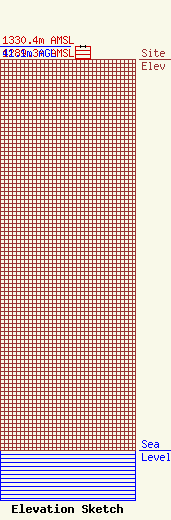
Site Elevation: 1289.3 meters (4230 ft) |
| Height of Structure: 41.1 meters (135 feet) |
| Overall Height Above Ground: 41.1 meters (135 feet) |
| Overall Height Above Mean Sea Level: 1330.4 meters (4365 feet) |
| Owner Info | Cumulus Radio, LLC
3280 Peachtree Rd, Suite 2200
Atlanta, GA 30305
(404) 949-0700
towermanagement@cumulus.com |
| Contact Info | Cumulus Radio, LLC
9801 Westheimer Rd
Houston, TX 77042
Robert Combs
(281) 755-4366
robert.combs@cumulus.com |
