|
|
Antenna Structure Registration 1317367 |
 |
Registration Info | Registration Number: 1317367 |
| File Number: A1173932 |
| FAA Study: 2020-ASW-9366-OE |
| FAA Issue Date: 07/20/2020 |
| Status: Granted |
Structure Info
| Structure Type: 2LTA2 |
| Structure Coordinates: 33-2-27.9 N 96-56-45.5 W (NAD 83) |
| Structure Coordinates: 33-02-27.5 N 96-56-44.5 W (Converted to NAD 27) |
| Structure Address: Off State Highway 121 |
| Structure City: Lewisville, TX |
| Structure County: Denton County |
| Painting & Lighting Info |
FAA Circular #: 70/7460-1L |
FAA Chapters: 3, 4, 5, 12 |
Remarks: PRIOR STUDY 2020-ASW-8177-OE |
| Elevation Info |
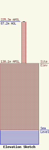
Site Elevation: 138.1 meters (453 ft) |
| Height of Structure: 86.3 meters (283 feet) |
| Overall Height Above Ground: 87.2 meters (286 feet) |
| Overall Height Above Mean Sea Level: 225.3 meters (739 feet) |
| Owner Info | Bison Media, Inc.
4880 Santa Rosa Road, Suite 300
Camarillo, CA 93012
(805) 384-4502
Scott.Foster@salemmedia.com |
| Contact Info | Bison Media, Inc.
4880 Santa Rosa Road, Suite 300
Camarillo, CA 93012
(805) 384-4502
Scott.Foster@salemmedia.com |
