|
|
Antenna Structure Registration 1318403 |
 |
Registration Info | Registration Number: 1318403 |
| File Number: A1184812 |
| FAA Study: 2020-ASW-1283-OE |
| FAA Issue Date: 05/05/2020 |
| Status: Constructed |
| Date Constructed: 01/01/2002 |
Structure Info
| Structure Type: LTOWER |
| Structure Coordinates: 34-52-0.9 N 92-23-43.6 W (NAD 83) |
| Structure Coordinates: 34-52-00.6 N 92-23-43.0 W (Converted to NAD 27) |
| Structure Address: 1001 Murphy Dr. |
| Structure City: Maumelle, AR |
| Structure County: Pulaski County |
| Painting & Lighting Info |
FAA Chapters: NONE |
| Elevation Info |
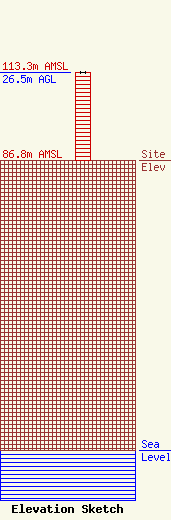
Site Elevation: 86.8 meters (285 ft) |
| Height of Structure: 26.5 meters (87 feet) |
| Overall Height Above Ground: 26.5 meters (87 feet) |
| Overall Height Above Mean Sea Level: 113.3 meters (372 feet) |
| Owner Info | CTI Towers Assets II, LLC
5000 Centre Green way
Cary, NC 27511
(919) 893-2841
mbertolino@ctitowers.com |
| Contact Info | CTI Towers Assets II, LLC
5000 Centre Green way
Cary, NC 27511
Matthew Bertolino
(919) 893-2841
mbertolino@ctitowers.com |
