|
|
Antenna Structure Registration 1319884 |
 |
Registration Info | Registration Number: 1319884 |
| File Number: A1192493 |
| FAA Study: 2019-AWP-9147-OE |
| FAA Issue Date: 08/21/2019 |
| Status: Granted |
Structure Info
| Structure Type: BANT |
| Structure Coordinates: 34-6-9.5 N 118-5-53.2 W (NAD 83) |
| Structure Coordinates: 34-06-09.5 N 118-05-50.0 W (Converted to NAD 27) |
| Structure Address: 128 East Las Tunas Drive (ie04395a) |
| Structure City: San Gabriel, CA |
| Structure County: Los Angeles County |
| Painting & Lighting Info |
FAA Chapters: NONE |
| Elevation Info |
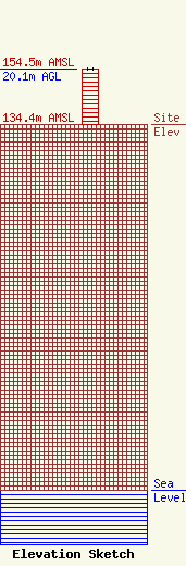
Site Elevation: 134.4 meters (441 ft) |
| Height of Structure: 20.1 meters (66 feet) |
| Overall Height Above Ground: 20.1 meters (66 feet) |
| Overall Height Above Mean Sea Level: 154.5 meters (507 feet) |
| Owner Info | T-Mobile West LLC
12920 SE 38th Street
Bellevue, WA 98006
(425) 383-8401
FCCRegulatoryComplianceContact@T-Mobile.com |
| Contact Info | T-Mobile West LLC
12920 SE 38th Street
Bellevue, WA 98006
(425) 383-8401
FCCRegulatoryComplianceContact@T-Mobile.com |
