|
|
Antenna Structure Registration 1320167 |
 |
Registration Info | Registration Number: 1320167 |
| File Number: A1193253 |
| FAA Study: 2021-AWP-5698-OE |
| FAA Issue Date: 05/13/2021 |
| Status: Granted |
Structure Info
| Structure Type: BANT |
| Structure Coordinates: 34-9-44.9 N 118-10-5.3 W (NAD 83) |
| Structure Coordinates: 34-09-44.9 N 118-10-02.0 W (Converted to NAD 27) |
| Structure Address: 1189 Rose Bowl Dr (layh011a) |
| Structure City: Pasadena, CA |
| Structure County: Los Angeles County |
| Painting & Lighting Info |
FAA Chapters: NONE |
Remarks: PRIOR STUDY 2001-AWP-3213-OE |
| Elevation Info |
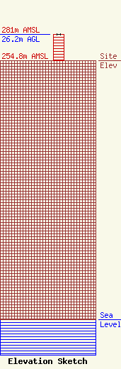
Site Elevation: 254.8 meters (836 ft) |
| Height of Structure: 26.2 meters (86 feet) |
| Overall Height Above Ground: 26.2 meters (86 feet) |
| Overall Height Above Mean Sea Level: 281 meters (922 feet) |
| Owner Info | T-Mobile West LLC
12920 SE 38th Street
Bellevue, WA 98006
(425) 383-8401
FCCRegulatoryComplianceContact@T-mobile.com |
| Contact Info | T-Mobile West LLC
12920 SE 38th Street
Bellevue, WA 98006
(425) 383-8401
FCCRegulatoryComplianceContact@T-mobile.com |
