|
|
Antenna Structure Registration 1323237 |
 |
Registration Info | Registration Number: 1323237 |
| File Number: A1237132 |
| FAA Study: 2022-ASW-13072-OE |
| FAA Issue Date: 01/03/2023 |
| Status: Constructed |
| Date Constructed: 01/19/2023 |
Structure Info
| Structure Type: MTOWER |
| Structure Coordinates: 34-50-31.7 N 92-29-47.5 W (NAD 83) |
| Structure Coordinates: 34-50-31.4 N 92-29-46.9 W (Converted to NAD 27) |
| Structure Address: 9799 Hwy 300 |
| Structure City: Roland, AR |
| Structure County: Pulaski County |
| Painting & Lighting Info |
FAA Chapters: NONE |
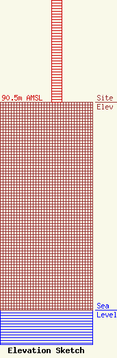
| Elevation Info |
Site Elevation: 90.5 meters (297 ft) |
| Height of Structure: 45.7 meters (150 feet) |
| Overall Height Above Ground: 48.5 meters (159 feet) |
| Overall Height Above Mean Sea Level: 139 meters (456 feet) |
| Owner Info | Tillman Infrastructure, LLC
152 West 57th Street
New York, NY 10019
(212) 706-1677
dmstipo@tillmaninfrastructure.com |
| Contact Info | Tillman Infrastructure, LLC
152 West 57th Street
New York, NY 10019
(212) 706-1677
dmstipo@tillmaninfrastructure.com |
