|
|
Antenna Structure Registration 1328901 |
 |
Registration Info | Registration Number: 1328901 |
| File Number: A1325922 |
| FAA Study: 2025-AWP-10634-OE |
| FAA Issue Date: 07/28/2025 |
| Status: Constructed |
| Date Constructed: 03/22/2025 |
Structure Info
| Structure Type: RIG |
| Structure Coordinates: 34-7-13.6 N 118-3-59.6 W (NAD 83) |
| Structure Coordinates: 34-07-13.6 N 118-03-56.4 W (Converted to NAD 27) |
| Structure Address: 9501 Lemon Ave |
| Structure City: Temple City, CA |
| Structure County: Los Angeles County |
| Painting & Lighting Info |
FAA Chapters: NONE |
Remarks: PRIOR STUDY 2024-AWP-6272-OE |
| Elevation Info |
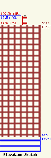
Site Elevation: 147 meters (482 ft) |
| Height of Structure: 11.6 meters (38 feet) |
| Overall Height Above Ground: 12.5 meters (41 feet) |
| Overall Height Above Mean Sea Level: 159.5 meters (523 feet) |
| Owner Info | Los Angeles SMSA Limited Partnership
5055 North Point Pkwy
Alpharetta, GA 30022
(770) 797-1070
NetworkRegulatory@VerizonWireless.com |
| Contact Info | Los Angeles SMSA Limited Partnership
5055 North Point Pkwy
Alpharetta, GA 30022
Regulatory Manager
(770) 797-1070
NetworkRegulatory@VerizonWireless.com |
