|
|
Antenna Structure Registration 1329630 |
 |
Registration Info | Registration Number: 1329630 |
| File Number: A1325467 |
| FAA Study: 2024-ASW-14599-OE |
| FAA Issue Date: 11/13/2024 |
| Status: Granted |
Structure Info
| Structure Type: LTOWER |
| Structure Coordinates: 34-43-19.2 N 92-26-26.1 W (NAD 83) |
| Structure Coordinates: 34-43-18.9 N 92-26-25.5 W (Converted to NAD 27) |
| Structure Address: 17324 Cooper Orbit Road Ar-5185 |
| Structure City: Big Rock Township, AR |
| Structure County: Pulaski County |
| Painting & Lighting Info |
FAA Circular #: 70/7460-1M |
FAA Chapters: 4, 8, 15 |
Remarks: PRIOR STUDY 2024-ASW-13048-OE |
| Elevation Info |
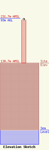
Site Elevation: 138.7 meters (455 ft) |
| Height of Structure: 89.9 meters (295 feet) |
| Overall Height Above Ground: 93 meters (305 feet) |
| Overall Height Above Mean Sea Level: 231.7 meters (760 feet) |
| Owner Info | VB BTS III, LLC
22 W Atlantic Ave Suite 310
DELRAY BEACH, FL 33444
(561) 405-4015
fcc-faa@verticalbridge.com |
| Contact Info | VB BTS III, LLC
22 W Atlantic Ave Suite 310
DELRAY BEACH, FL 33444
Richard Hickey
(561) 405-4015
fcc-faa@verticalbridge.com |
