|
|
Antenna Structure Registration 1000011 |
 |
Registration Info | Registration Number: 1000011 |
| File Number: A0000031 |
| FAA Study: 96-ASO-2153-OE |
| FAA Issue Date: 06/10/1996 |
| Status: Constructed |
| Date Constructed: 08/10/1996 |
| FAA EMI: Y |
| NEPA: N |
Structure Info
| Structure Type: TOWER |
| Structure Coordinates: 38-11-45.0 N 85-41-4.0 W (NAD 83) |
| Structure Coordinates: 38-11-44.7 N 85-41-04.1 W (Converted to NAD 27) |
| Structure Address: Se Cor Atkinson Dr And Bishop Ln |
| Structure City: Louisville, KY |
| Structure County: Jefferson County |
| Painting & Lighting Info |
FAA Chapters: NONE |
| Elevation Info |
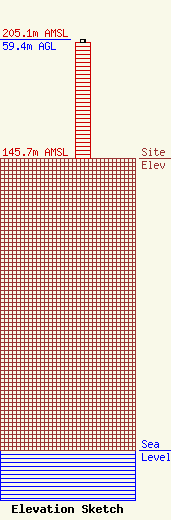
Site Elevation: 145.7 meters (478 ft) |
| Height of Structure: 57.9 meters (190 feet) |
| Overall Height Above Ground: 59.4 meters (195 feet) |
| Overall Height Above Mean Sea Level: 205.1 meters (673 feet) |
| Owner Info | FIFTEEN TELECOMMUNICATIONS INC DBA = WKPC TV
37380
LOUISVILLE, KY 40233
(502) 394-3510
|
