|
|
Antenna Structure Registration 1000798 |
 |
Registration Info | Registration Number: 1000798 |
| File Number: A1035208 |
| FAA Study: 2003-ASO-1930-OE |
| FAA Issue Date: 06/06/2003 |
| Status: Constructed |
| Date Constructed: 12/15/1997 |
| FAA EMI: N |
| NEPA: N |
Structure Info
|
| Structure Coordinates: 34-14-15.1 N 84-9-27.0 W (NAD 83) |
| Structure Coordinates: 34-14-14.8 N 84-09-27.3 W (Converted to NAD 27) |
| Structure Address: 240 Tower Road (sawnee Mt / 026130) |
| Structure City: Cumming, GA |
| Structure County: Forsyth County |
| Painting & Lighting Info |
FAA Circular #: 70/7460-1J |
FAA Chapters: 4, 5, 6, 8, 13 |
Remarks: PRIOR STUDY 2002-ASO-3547-OE |
Remarks: OM&L TO REMAIN THE SAME AS PRIOR STUDY = A MED-DUAL SYSTEM |
Remarks: PRIOR STUDY 2002-ASO-3547-OE |
Remarks: OM&L TO REMAIN THE SAME AS PRIOR STUDY = A MED-DUAL SYSTEM |
| Elevation Info |
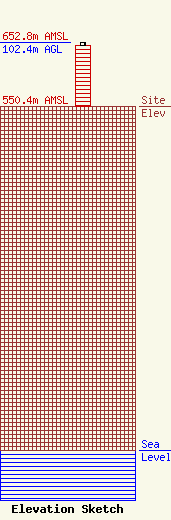
Site Elevation: 550.4 meters (1806 ft) |
| Height of Structure: 97.5 meters (320 feet) |
| Overall Height Above Ground: 102.4 meters (336 feet) |
| Overall Height Above Mean Sea Level: 652.8 meters (2142 feet) |
| W248BV C/R Height Above Mean Sea Level: 0 meters (0 ft)
|
| Owner Info | American Towers LLC
10 Presidential Way
Woburn, MA 01801
(781) 962-4500
faa-fcc@americantower.com |
| Contact Info | American Towers, LLC
10 Presidential Way
Woburn, MA 01801
(781) 962-4500
faa-fcc@americantower.com |
