|
|
Antenna Structure Registration 1001697 |
 |
Registration Info | Registration Number: 1001697 |
| File Number: A1226453 |
| FAA Study: 2021-ASO-51595-OE |
| FAA Issue Date: 10/19/2022 |
| Status: Constructed |
| Date Constructed: 09/30/1996 |
| NEPA: N |
Structure Info
| Structure Type: LTOWER |
| Structure Coordinates: 35-47-21.1 N 78-40-44.5 W (NAD 83) |
| Structure Coordinates: 35-47-20.6 N 78-40-45.5 W (Converted to NAD 27) |
| Structure Address: 3101 Hillsborough St (site # 372921) |
| Structure City: Raleigh, NC |
| Structure County: Wake County |
| Painting & Lighting Info |
FAA Circular #: 70/7460-1K |
FAA Chapters: 4, 8, 12 |
Remarks: PRIOR STUDY 2021-ASO-30656-OE |
Remarks: OM&L to remain the same as prior study = A MED-DUAL SYSTEM |
Remarks: PRIOR STUDY 2021-ASO-30656-OE |
| Elevation Info |
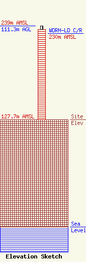
Site Elevation: 127.7 meters (419 ft) |
| Height of Structure: 107 meters (351 feet) |
| Overall Height Above Ground: 111.3 meters (365 feet) |
| Overall Height Above Mean Sea Level: 239 meters (784 feet) |
| WDRH-LD C/R Height Above Mean Sea Level: 230 meters (755 ft)
|
| Owner Info | American Towers LLC
10 Presidential Way
Woburn, MA 01801
(781) 926-4500
faa-fcc@americantower.com |
| Contact Info | American Towers LLC
10 Presidential Way
Woburn, MA 01801
(781) 926-4500
faa-fcc@americantower.com |
