|
|
Antenna Structure Registration 1001783 |
 |
Registration Info | Registration Number: 1001783 |
| File Number: A1262506 |
| FAA Study: 2022-ASW-8093-OE |
| FAA Issue Date: 01/17/2023 |
| Status: Constructed |
| Date Constructed: 04/27/1997 |
| NEPA: N |
Structure Info
| Structure Type: GTOWER |
| Structure Coordinates: 29-48-6.2 N 95-14-3.8 W (NAD 83) |
| Structure Coordinates: 29-48-05.4 N 95-14-03.0 W (Converted to NAD 27) |
| Structure Address: 11304 Clara 2/3 Road (004212) |
| Structure City: Houston, TX |
| Structure County: Harris County |
| Painting & Lighting Info |
FAA Circular #: 70/7460-1L |
FAA Chapters: 4, 8, 12 |
Remarks: PRIOR STUDY 2016-ASW-9065-OE |
Remarks: OM&L to remain the same as prior study = A MED-DUAL SYSTEM |
Remarks: PRIOR STUDY 2016-ASW-9065-OE |
Remarks: OM&L to remain the same as prior study = A MED-DUAL SYSTEM |
| Elevation Info |
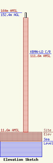
Site Elevation: 11.6 meters (38 ft) |
| Height of Structure: 146 meters (479 feet) |
| Overall Height Above Ground: 152.4 meters (500 feet) |
| Overall Height Above Mean Sea Level: 164 meters (538 feet) |
| KBMN-LD C/R Height Above Mean Sea Level: 111.6 meters (366 ft)
|
| Owner Info | American Towers LLC
10 Presidential Way
Woburn, MA 01801
(781) 926-4500
faa-fcc@americantower.com |
| Contact Info | American Towers LLC
10 Presidential Way
Woburn, MA 01801
(781) 926-4500
faa-fcc@americantower.com |
