|
|
Antenna Structure Registration 1002070 |
 |
Registration Info | Registration Number: 1002070 |
| File Number: A1297261 |
| FAA Study: 86-AWP-009-OE |
| Status: Constructed |
| Date Constructed: 05/01/1986 |
| FAA EMI: N |
| NEPA: N |
Structure Info
| Structure Type: TOWER |
| Structure Coordinates: 33-20-1.0 N 112-3-48.0 W (NAD 83) |
| Structure Coordinates: 33-20-00.8 N 112-03-45.5 W (Converted to NAD 27) |
| Structure Address: South Mountain Antenna Farm Approx 8 Mi S |
| Structure City: Phoenix, AZ |
| Structure County: Maricopa County |
| Painting & Lighting Info |
FAA Circular #: 70/7460-1G |
FAA Chapters: 3, 4, 5, 9 |
| Elevation Info |
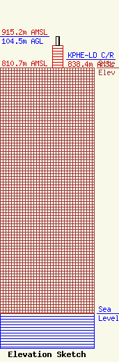
Site Elevation: 810.7 meters (2660 ft) |
| Height of Structure: 74 meters (243 feet) |
| Overall Height Above Ground: 104.5 meters (343 feet) |
| Overall Height Above Mean Sea Level: 915.2 meters (3003 feet) |
| KPHE-LD C/R Height Above Mean Sea Level: 838.4 meters (2751 ft)
|
| Owner Info | Gray Local Media, Inc.
4370 Peachtree Road, NE
Atlanta, GA 30319
(404) 266-8333
legalnotices@graymedia.com |
| Contact Info | Gray Local Media, Inc.
4370 Peachtree Road NE
Atlanta, GA 30319
Engineering Department
(404) 266-8333
legalnotices@graymedia.com |
