|
|
Antenna Structure Registration 1002313 |
 |
Registration Info | Registration Number: 1002313 |
| File Number: A1093421 |
| FAA Study: 2017-ASO-18296-OE |
| FAA Issue Date: 09/18/2017 |
| Status: Constructed |
| Date Constructed: 01/01/1984 |
| NEPA: N |
Structure Info
| Structure Type: GTOWER |
| Structure Coordinates: 32-3-55.1 N 81-21-5.1 W (NAD 83) |
| Structure Coordinates: 32-03-54.4 N 81-21-05.7 W (Converted to NAD 27) |
| Structure Address: On Falcon Lane, East Of Fort Argyle Road; 9 Km South Of Bloomingdale, Ga. |
| Structure City: Bloomingdale, GA |
| Structure County: Chatham County |
| Painting & Lighting Info |
FAA Circular #: 70/7460-1L |
FAA Chapters: 3, 4, 5, 12 |
Remarks: PRIOR STUDY 2014-ASO-2467-OE |
| Elevation Info |
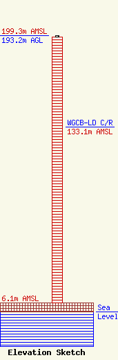
Site Elevation: 6.1 meters (20 ft) |
| Height of Structure: 192.3 meters (631 feet) |
| Overall Height Above Ground: 193.2 meters (634 feet) |
| Overall Height Above Mean Sea Level: 199.3 meters (654 feet) |
| WGCB-LD C/R Height Above Mean Sea Level: 133.1 meters (437 ft)
|
| Owner Info | BIBLE BROADCASTING NETWORK, INC.
11530 CARMEL COMMONS BLVD.
CHARLOTTE, NC 28226
(704) 523-5555
JPADGETT@BBNMEDIA.ORG |
| Contact Info | BIBLE BROADCASTING NETWORK, INC.
11530 CARMEL COMMONS BVLD.
CHARLOTTE, NC 28226
JASON PADGETT
(704) 523-5555
JPADGETT@BBNMEDIA.ORG |
