|
|
Antenna Structure Registration 1002832 |
 |
Registration Info | Registration Number: 1002832 |
| File Number: A1207391 |
| FAA Study: 2021-ASW-11355-OE |
| FAA Issue Date: 10/12/2021 |
| Status: Constructed |
| Date Constructed: 01/01/1989 |
| NEPA: N |
Structure Info
| Structure Type: GTOWER |
| Structure Coordinates: 32-47-12.5 N 103-7-5.0 W (NAD 83) |
| Structure Coordinates: 32-47-12.1 N 103-07-03.2 W (Converted to NAD 27) |
| Structure Address: 7520 Casa Bonita (#208264) |
| Structure City: Hobbs, NM |
| Structure County: Lea County |
| Painting & Lighting Info |
FAA Circular #: 70/7460-1M |
FAA Chapters: 4, 8, 15 |
Remarks: PRIOR STUDY 2013-ASW-2510-OE |
| Elevation Info |
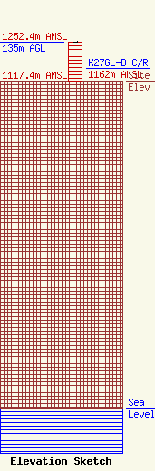
Site Elevation: 1117.4 meters (3666 ft) |
| Height of Structure: 133.5 meters (438 feet) |
| Overall Height Above Ground: 135 meters (443 feet) |
| Overall Height Above Mean Sea Level: 1252.4 meters (4109 feet) |
| K27GL-D C/R Height Above Mean Sea Level: 1162 meters (3812 ft)
|
| Owner Info | American Towers LLC
10 Presidential Way
Woburn, MA 01801
(781) 926-4500
faa-fcc@americantower.com |
| Contact Info | American Towers LLC
10 Presidential Way
Woburn, MA 01801
(781) 926-4500
faa-fcc@americantower.com |
