|
|
Antenna Structure Registration 1002840 |
 |
Registration Info | Registration Number: 1002840 |
| File Number: A1229703 |
| FAA Study: 2021-ASW-11364-OE |
| FAA Issue Date: 12/07/2021 |
| Status: Constructed |
| Date Constructed: 01/01/1990 |
| NEPA: N |
Structure Info
| Structure Type: GTOWER |
| Structure Coordinates: 32-26-9.6 N 104-11-16.0 W (NAD 83) |
| Structure Coordinates: 32-26-09.2 N 104-11-14.2 W (Converted to NAD 27) |
| Structure Address: 1609 East Greene Street (#209753) |
| Structure City: Carlsbad, NM |
| Structure County: Eddy County |
| Painting & Lighting Info |
FAA Circular #: 70/7460-1M |
FAA Chapters: 4, 8, 15 |
Remarks: PRIOR STUDY 2014-ASW-3512-OE |
| Elevation Info |
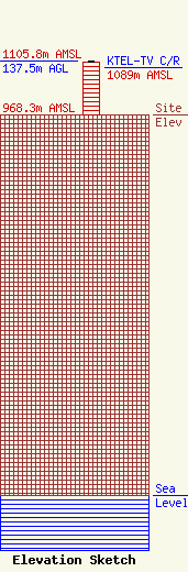
Site Elevation: 968.3 meters (3177 ft) |
| Height of Structure: 134.4 meters (441 feet) |
| Overall Height Above Ground: 137.5 meters (451 feet) |
| Overall Height Above Mean Sea Level: 1105.8 meters (3628 feet) |
| KTEL-TV C/R Height Above Mean Sea Level: 1089 meters (3573 ft)
|
| Owner Info | American Towers LLC
10 Presidential Way
Woburn, MA 01801
(781) 926-4500
faa-fcc@americantower.com |
| Contact Info | American Towers LLC
10 Presidential Way
Woburn, MA 01801
(781) 926-4500
faa-fcc@americantower.com |
