|
|
Antenna Structure Registration 1003214 |
 |
Registration Info | Registration Number: 1003214 |
| File Number: A1102056 |
| FAA Study: 2018-AEA-4954-OE |
| FAA Issue Date: 04/20/2018 |
| Status: Constructed |
| Date Constructed: 03/15/2002 |
| NEPA: N |
Structure Info
| Structure Type: GTOWER |
| Structure Coordinates: 42-8-17.0 N 75-59-57.8 W (NAD 83) |
| Structure Coordinates: 42-08-16.7 N 75-59-59.1 W (Converted to NAD 27) |
| Structure Address: 1190 Robinson Hill Road / Us-ny-5032 |
| Structure City: Johnson City, NY |
| Structure County: Broome County |
| Painting & Lighting Info |
FAA Circular #: 70/7460-1L |
FAA Chapters: 4, 8, 12 |
Remarks: PRIOR STUDY 1997-AEA-4038-OE |
| Elevation Info |
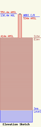
Site Elevation: 414 meters (1358 ft) |
| Height of Structure: 134.6 meters (442 feet) |
| Overall Height Above Ground: 136.4 meters (448 feet) |
| Overall Height Above Mean Sea Level: 550.4 meters (1806 feet) |
| WBBI C/R Height Above Mean Sea Level: 534 meters (1752 ft)
|
| Owner Info | Vertical Bridge CC FM, LLC
750 Park of Commerce Dr.
Boca Raton, FL 33487
(561) 406-4015
FCC-FAA@verticalbridge.com |
| Contact Info | Vertical Bridge CC FM, LLC
750 Park of Commerce Dr.
Boca Raton, FL 33487
Richard Hickey
(561) 406-4015
FCC-FAA@verticalbridge.com |
