|
|
Antenna Structure Registration 1003752 |
 |
Registration Info | Registration Number: 1003752 |
| File Number: A0429022 |
| FAA Study: 94-AGL-2274-OE |
| FAA Issue Date: 07/08/1994 |
| Status: Constructed |
| Date Constructed: 07/01/1982 |
| FAA EMI: N |
| NEPA: N |
Structure Info
| Structure Type: TOWER |
| Structure Coordinates: 45-10-49.0 N 85-5-50.0 W (NAD 83) |
| Structure Coordinates: 45-10-49.0 N 85-05-49.8 W (Converted to NAD 27) |
| Structure Address: Richardson Hill 2 N Mi Ne |
| Structure City: East Jordan, MI |
| Structure County: Charlevoix County |
| Painting & Lighting Info |
FAA Circular #: 70/7460-1H |
FAA Chapters: 3, 4, 5, 13 |
| Elevation Info |
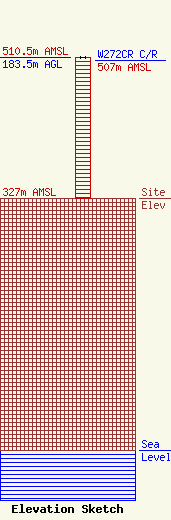
Site Elevation: 327 meters (1073 ft) |
| Height of Structure: 183.1 meters (601 feet) |
| Overall Height Above Ground: 183.5 meters (602 feet) |
| Overall Height Above Mean Sea Level: 510.5 meters (1675 feet) |
| W272CR C/R Height Above Mean Sea Level: 507 meters (1663 ft)
|
| Owner Info | MacDonald Garber Broadcasting, Inc.
2095 U.S. 131 South
Petoskey, MI 49770
(231) 347-8713
tmac@106khq.com |
| Info |
