|
|
Antenna Structure Registration 1003996 |
 |
Registration Info | Registration Number: 1003996 |
| File Number: A0652500 |
| FAA Study: 2007-AEA-2800-OE |
| FAA Issue Date: 08/27/2007 |
| Status: Constructed |
| Date Constructed: 11/01/2007 |
| FAA EMI: N |
| NEPA: N |
Structure Info
| Structure Type: TOWER |
| Structure Coordinates: 43-6-4.0 N 76-16-57.0 W (NAD 83) |
| Structure Coordinates: 43-06-03.8 N 76-16-58.3 W (Converted to NAD 27) |
| Structure Address: Off Van Buren Rd |
| Structure City: Warners, NY |
| Structure County: Onondaga County |
| Painting & Lighting Info |
FAA Circular #: 70/7460-1K |
FAA Chapters: 4, 8, 12 |
Remarks: PRIOR STUDY 2001-AEA-2850-OE |
Remarks: Removed expiration and final dates from determination. Scenario 2./jjs/case#635066 |
Remarks: PRIOR STUDY 2001-AEA-2850-OE |
Remarks: Removed expiration and final dates from determination. Scenario 2./jjs/case#635066 |
| Elevation Info |
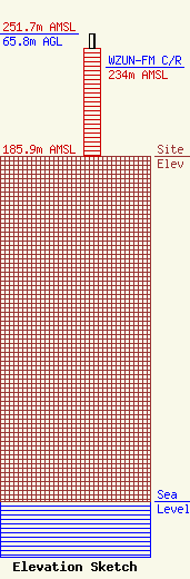
Site Elevation: 185.9 meters (610 ft) |
| Height of Structure: 57.9 meters (190 feet) |
| Overall Height Above Ground: 65.8 meters (216 feet) |
| Overall Height Above Mean Sea Level: 251.7 meters (826 feet) |
| WZUN-FM C/R Height Above Mean Sea Level: 234 meters (768 ft)
|
| Owner Info | DBA J ELECTRONICS
2700 Jubal Early Highway
Boones Mill, VA 24065
John Relyea
(315) 395-0501
|
| Contact Info | Fiorio Communications Consulting
198
Clarksville, MD 21029
Pete Fiorio
(240) 793-2110
pf@fioriocom.com |
