|
|
Antenna Structure Registration 1004282 |
 |
Registration Info | Registration Number: 1004282 |
| File Number: A0005034 |
| FAA Study: 85-AEA-1249-OE |
| FAA Issue Date: 08/14/1986 |
| Status: Granted |
| Date Constructed: 01/01/1986 |
| NEPA: N |
Structure Info
| Structure Type: TOWER |
| Structure Coordinates: 43-9-17.0 N 77-36-9.0 W (NAD 83) |
| Structure Coordinates: 43-09-16.8 N 77-36-10.0 W (Converted to NAD 27) |
| Structure Address: One Marine Midland Plz |
| Structure City: Rochester, NY |
| Structure County: Monroe County |
| Painting & Lighting Info |
FAA Circular #: 70/7460-1G |
FAA Chapters: 3, 4, 5, 9 |
| Elevation Info |
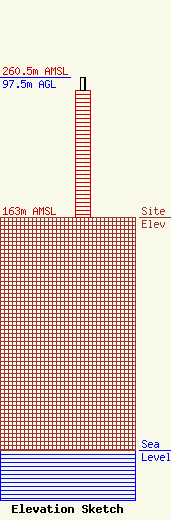
Site Elevation: 163 meters (535 ft) |
| Height of Structure: 88.7 meters (291 feet) |
| Overall Height Above Ground: 97.5 meters (320 feet) |
| Overall Height Above Mean Sea Level: 260.5 meters (855 feet) |
| Owner Info | BENDERSON ROCHESTER ASSOCIATES LCC
ONE MARINE MIDLAND PLZ
ROCHESTER, NY 14604
(410) 454-3280
|
