|
|
Antenna Structure Registration 1005062 |
 |
Registration Info | Registration Number: 1005062 |
| File Number: A1297271 |
| FAA Study: 82-ASO-30-OE |
| FAA Issue Date: 07/26/1984 |
| Status: Constructed |
| Date Constructed: 11/19/1984 |
| FAA EMI: N |
| NEPA: N |
Structure Info
| Structure Type: TOWER |
| Structure Coordinates: 35-21-51.0 N 81-11-12.0 W (NAD 83) |
| Structure Coordinates: 35-21-50.5 N 81-11-12.7 W (Converted to NAD 27) |
| Structure Address: Rt 3 Bob Friday Rd |
| Structure City: Dallas, NC |
| Structure County: Gaston County |
| Painting & Lighting Info |
FCC Paragraph(s): A1, B, G, H |
Remarks: HIGH INTENSITY WHITE LIGHTS |
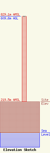
| Elevation Info |
Site Elevation: 219.5 meters (720 ft) |
| Height of Structure: 609.6 meters (2000 feet) |
| Overall Height Above Ground: 609.6 meters (2000 feet) |
| Overall Height Above Mean Sea Level: 829.1 meters (2720 feet) |
| Owner Info | Gray Local Media, Inc.
4370 Peachtree Road, NE
Atlanta, GA 30319
(404) 266-8333
legalnotices@graymedia.com |
| Contact Info | Gray Local Media, Inc.
4370 Peachtree Road NE
Atlanta, GA 30319
Engineering Department
(404) 266-8333
legalnotices@graymedia.com |
